
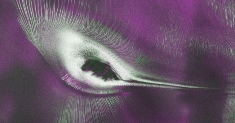
Hidden beneath Antarctica’s endless expanse of ice lies a surprising formation that looks like it was painted onto the frozen landscape — a giant hummingbird revealed from space. Using advanced satellite technology, NASA has captured a remarkable pattern shaped by millions of years of glacial activity, offering scientists a rare glimpse into the secrets buried beneath the continent’s icy surface. But the strange bird-like feature is more than just a visual wonder, it highlights how powerful imaging tools of today are transforming the way researchers explore Earth’s most remote environments
Hummingbird-like shape in Antarctica revealed
A stunning satellite image has captured the attention of space enthusiasts around the world after revealing what appears to be a giant hummingbird hidden within Antarctica’s frozen landscape. While the formation may resemble a familiar flying creature, the image is actually a remarkable example of how advanced technology can uncover the unexpected beauty and complexity of Earth’s most remote regions.
The discovery was made using data collected by the NASA-ISRO Synthetic Aperture Radar (NISAR), a collaborative mission between NASA and the Indian Space Research Organisation (ISRO). The satellite carries two sophisticated radar instruments designed to capture detailed observations of Earth’s surface, even through challenging conditions such as ice, clouds, and darkness.
According to NASA, teams from the United States and India used radar data from NISAR to produce highly detailed images of Antarctica’s rugged terrain. The technology is designed to help researchers monitor the movement of Earth’s land and ice, study environmental changes in ecosystems such as forests and wetlands, and improve responses to natural events including landslides and earthquakes.
The natural forces that created Antarctica’s ‘Hummingbird’
The striking image represents a rare intersection of scientific discovery and visual coincidence. What appears to be a hummingbird frozen into the Antarctic landscape is actually a natural geographic feature known as Nunatak Zaterjavshijsja, a mountain peak in East Antarctica that rises above a vast flow of moving ice.
“Despite its otherworldly quality, the Antarctic image shows a very real geographical feature called Nunatak Zaterjavshijsja, a mountaintop in East Antarctica, poking out amid a stream of ice flowing northeast to the ocean,” NASA said.
The bird-like appearance is created by the interaction between the mountain’s shape and the surrounding glacial environment. As the glacier slowly moves toward the ocean, the uneven terrain beneath the ice places pressure on the flowing ice sheet. This stress causes the ice to fracture, forming deep cracks known as crevasses.
In the satellite image, these crevasses appear as vibrant lines across the icy surface, helping create the illusion of a hummingbird’s wings and body when viewed from above.
Beyond its unusual appearance, the image demonstrates the scientific value of radar-based satellite observation. Unlike traditional cameras, radar instruments can detect subtle changes in Earth’s surface by measuring how microwave signals bounce back after interacting with different materials.
The colors displayed in the image reveal variations in how polarized the icy terrain reflects microwave signals. Differences in signal orientation — including vertical and horizontal polarization patterns represented by colors such as magenta and green — provide scientists with valuable clues about the shape, texture, and structure of the surface being studied.
Through this advanced imaging method, researchers can examine landscapes that would otherwise remain difficult to access, offering new insights into glaciers, mountains, and other hidden features across the planet.
A stunning image with scientific value
Although the Antarctic “hummingbird” is a coincidence created by nature, it represents something far more significant than an eye-catching satellite image. The discovery highlights how modern space technology allows scientists to explore Earth in unprecedented detail, revealing both the planet’s hidden mysteries and the forces that continue to shape its surface.
From tracking climate-related changes to studying remote environments, satellite radar imaging is opening a new window into the world beneath our feet, and sometimes, it reveals unexpected works of natural art along the way.
Source:
FOX Weather