
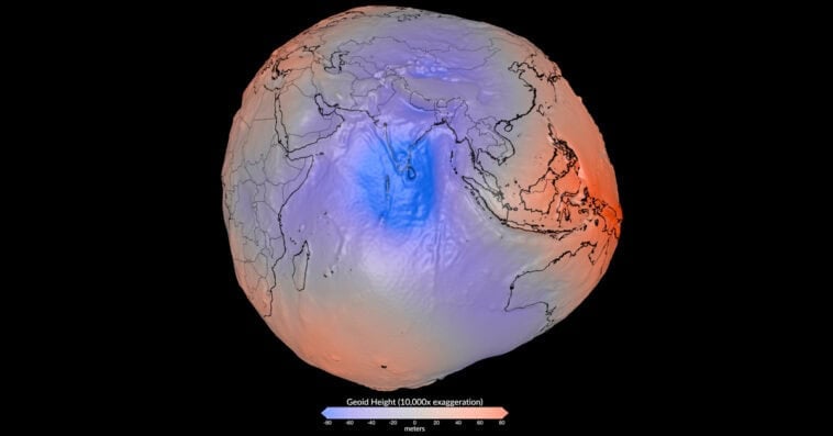
For centuries, Earth has been pictured as a near-perfect blue sphere floating through space — but a new high-precision gravity model is revealing a far stranger reality. Using detailed measurements of the planet’s gravitational field, scientists have created a visualization that makes Earth look less like a smooth globe and more like a lumpy potato. Read on to discover how invisible forces are reshaping our understanding of Earth’s true form and why our planet’s unusual shape matters more than you might think.
What are we actually looking at?
The viral image showing Earth with a strange, uneven potato-like appearance has sparked curiosity around the world, but the visualization does not represent the planet’s actual physical shape. Earth is still a nearly round world, slightly flattened at the poles due to its rotation. Instead, the image displays a scientific model called the geoid, a representation of how Earth’s surface would appear if it were shaped only by gravity and unaffected by tides, ocean currents, or winds.
The geoid helps scientists understand the invisible forces that influence our planet. Unlike a traditional globe, which presents Earth as a smooth sphere, this model reveals small variations in gravitational strength across different regions.
Earth’s uneven gravity creates ‘hills’ and ‘valleys’
The unusual bumps and dips seen in NASA’s model are linked to the uneven distribution of materials deep inside Earth. Some areas contain denser rocks and underground structures that create a slightly stronger gravitational pull, causing the geoid to rise and form what scientists describe as gravitational “hills.”
Meanwhile, areas with less dense material have weaker gravitational attraction, creating lower regions or gravitational “valleys.” These changes are extremely subtle, but they provide valuable clues about Earth’s internal composition and how mass is distributed beneath the surface.
To make these invisible differences easier to see, scientists dramatically enhanced the variations in NASA’s visualization. The changes were increased by a factor of 10,000, meaning the real differences in elevation are only measured in a few dozen yards — far too small for humans to notice by simply looking at the planet.
Mapping Earth’s gravity with space technology
The detailed geoid model was created through years of research and data collection using advanced satellite technology. Scientists combined measurements from missions such as the European Space Agency’s GOCE (Gravity field and steady-state Ocean Circulation Explorer) and NASA’s GRACE (Gravity Recovery and Climate Experiment) to study tiny changes in Earth’s gravitational field.
By analyzing more than a billion measurements gathered over 15 years, researchers built one of the most precise models ever created of Earth’s gravitational landscape.
The data revealed that Earth’s strongest gravitational “high” is located near Iceland, where the geoid rises approximately 279 feet above the global average. On the other side of the scale, a region south of India represents one of the lowest points, where the geoid falls about 348 feet below the average.
Why regular maps aren’t enough anymore
For centuries, mapmakers relied on a simplified model called an ellipsoid — essentially a smooth, slightly squished sphere that made basic math and map-building easy. While that works fine for a classroom wall map, modern technology requires far more detail.
Understanding the true, bumpy geoid is vital for modern life:
- Pinpoint Navigation: It helps ground-truth GPS systems, allowing everything from commercial airliners to self-driving technology to track altitude and position down to the millimeter.
- Tracking Climate Change: By establishing a true “zero line” for ocean height, scientists can accurately measure how fast sea levels are rising and how melting ice sheets alter the planet’s mass.
- Peering Underground: It gives geologists a way to study tectonic plates and underground magma flows without having to drill miles into the crust.
Although NASA’s geoid visualization makes Earth appear like a giant potato, it does not mean the planet is falling apart or physically distorted. Instead, the image is a powerful scientific tool that transforms invisible variations in gravity into a detailed map, helping researchers understand how Earth’s internal structure, surface features, and natural processes shape the world around us.
Source:
AS.com